Great Skellig

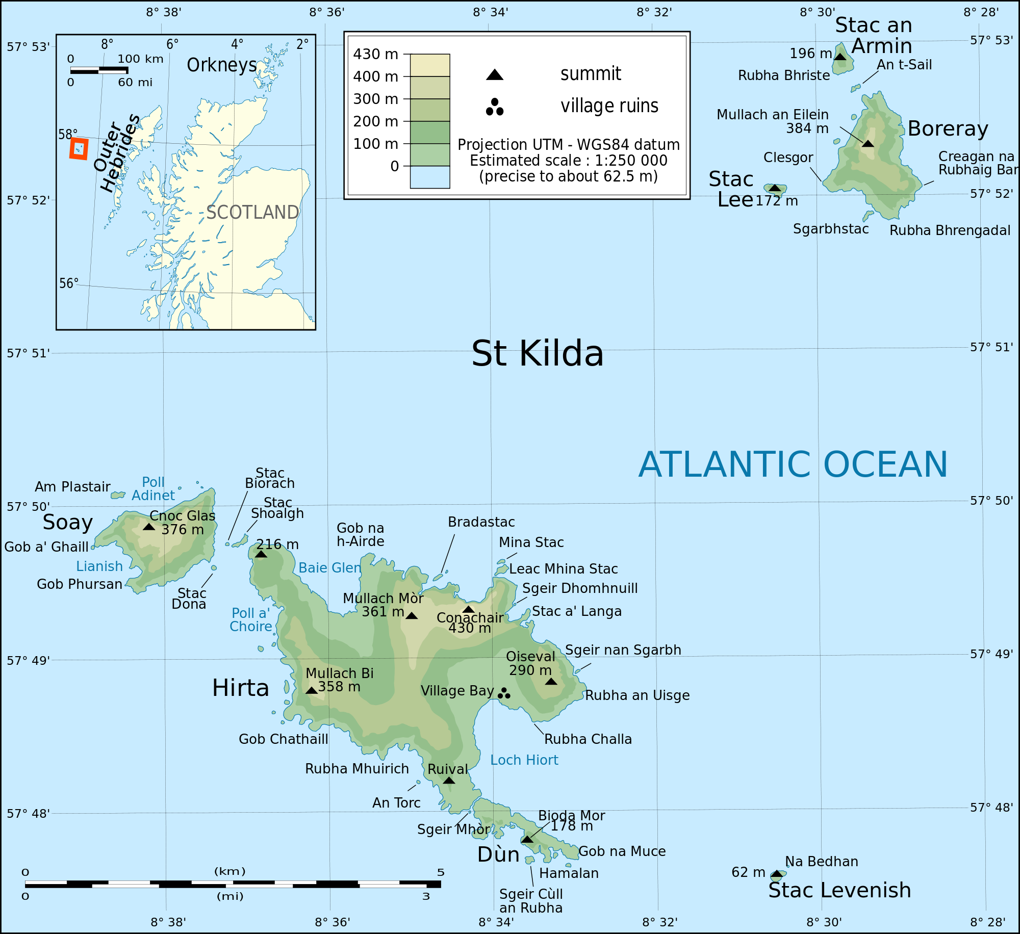
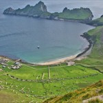
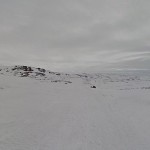
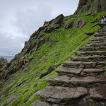
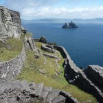
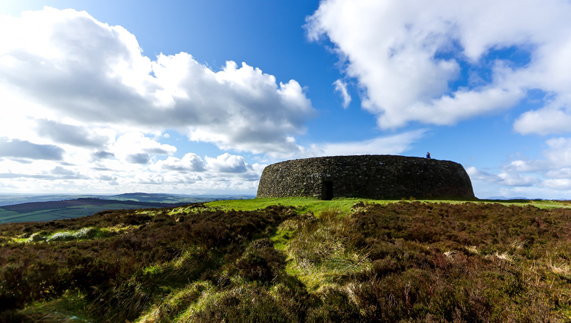
The island of Great Skellig, or Skellig Micheal, is an island off the coast of County Kerry, Ireland. The island is best known for its 7th century Christian monastery that is on the cliff of the island. The monastery helped show the early monastic ideals of living in a harsh life for Christ. In the 12th century a chapel was built on the island but was damaged greatly and is mostly in ruins island was abandoned, for reasons unknown, but it was believed that colder temperatures and more resilient storms resulted the monks to be moved to Ballinskelligs, on mainland in county Kerry. After they left the Order of Saint Augustine kept control of the island, in 1578 until Queen Elizabeth I, a protestant, gave control of the land the monks were living on to the Butler family, the butler dynasty is famous for fighting against the Irish in the Norman Invasion of Ireland. The Butler family kept control until the 1820’s, when the Corporation for Preserving and Improving the Port of Dublin bought the land from the family. Then the office of public works bought the island, excluding the lighthouses built by the Corporation for Preserving and Improving the Port of Dublin.

Monastary

The island is also protected by the UNESCO World Heritage Site. No one is allowed to live on the island so that the monastery and the birds that live on the island are not affected by human influence. However every year thirteen boats are allowed to give tours around the island and on the island but only in late spring to early fall, because of the weather. This has changed slightly, in 2014 the Irish Government allowed the filming of Star Wars Episode VII: The Force Awakens, to be done on the island. So is the filming of a film were people fight with swords that light up, giant star ships, and countless men in shiny white suits that run around with fake laser guns more important than the environment….

yes

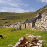
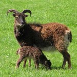
Their are also many birds that are protected on the island, some include black-tipped gannets which also breeds on the islands but mostly on little Skellig. Little Skellig is home of one of the worlds greatest gannetries, 27,000 pairs are believed to be on the island, people believe that because of the huge amounts of birds, the monks ,that originally were on the island, were able to harvest sea bird eggs. The birds were also collected by plundering parties in the 19th century and the owner of the little Skellig, the Butler family, hired guards to protect the birds. Another bird on the island was the puffin, similar to the gannet they too were plundered for their feathers, and meat but they lived on Great Skellig. Their are also razorbills, guillemots and most notable is the Manx shearwaters, and storm petrels, it is possibly that their population is largest in the world. Durning the summer months in the daytime the birds dominate the island, on all the cliffs you’ll see at least one of the types of birds that live on the island. During the night the birds return to there nests by the sound of their mates call. Some other animals that were introduced to the island were the rabbits, unknown date, and the fulmars did not arrive until 1913.

bird bird 5

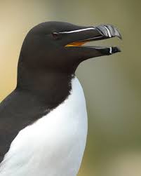
Razorbill ^                                   Guillemots^

bird 3 bird 4

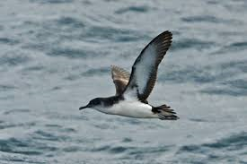
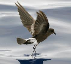
Manx shearwaters ^                                    storm petrels ^

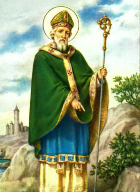
There are also many myths and legends that surround the islands it is believed that it was on Great Skellig were Saint Michael the Archangel and the Heavenly Host came to Saint Patrick and helped him drive the snakes out of Ireland. It also said that Great Skellig is were the King of the World, Duagh, rested before his battle of a year and a day against Finn MacCool at Ventry.

patrick

  • Dean Gandley and Barbara Feng
Posted in Uncategorized | Comments Off on Great Skellig

South Georgia


url.jpg

Aerial View of South Georgia

url.png

Map of South Georgia

Overview
          Larger than most of the islands we have looked at so far and also the most southern, South Georgia has a human history that started later compared to some of the other ice-covered islands Lovegrove discusses.The first encounter was on January 15, 1775 by Captain Cook who claimed this land for England. In fact, South Georgia is still a British-owned island.   As Lovegrove says in his introduction larger islands allow for more biogeography, at 100 miles long there are an estimated 35 million pairs of seabirds on the islands along with fur seals and unique wildlife such as elephant seals and king penguins. While these are the species native to this island, Europeans brought along their own reindeer and pigs for food purposes.
          The original stations that were set up for whalers and sealers to operate became towns in South Georgia such as Grytviken. The types of whales hunted were humpbacks, fin whales, gigantic blue whales and southern right whales on seven total whaling stations established on the island. In the 61 years of whaling on South Georgia (1904-1961) approximately 175,250 whales had been turned into whale oil and other items. With humans presence on South Georgia, it is inevitable that it was followed with an infestation with rats. Rats then led to problems for the seabird populations and native plant species because they eat eggs and anything else they can get. On South Georgia it especially has been a problem to eliminate the rats because of the size, climate of the island and the fact that no funding from the government has given South Georgia any support for their rat problem (Lovegrove 144). The island is economically self-sufficient with its fishery leading the way with a contribution from tourism to the island.

Shackleton
Ernest Shackleton was an explorer who was studying the island of South Georgia and then fell ill. On his trek back home to receive treatment, his ship was crushed by ice, resulting in him and his crew being stranded on ice for months until they reached Elephant Island. Shackleton eventually rescued his crew and all survived. Shackleton continued to go on Antarctic expeditions after this encounter and later died on another exploration in the Antarctic region.

Environment and Wildlife
There is a large push on the island for maintaining the existing biodiversity and the surrounding environment. Any actions people wish to take that could potentially damage the environment and those who undertake any activity that can do so without permission, including introducing non-native species, will be held accountable for their actions.

9711610319_df77622d93

Emperor Penguins Face Off an Elephant Seal

Elephant-seal-family

Elephant Seal Family

Tourism
Although the island is in the bitter cold, there are many companies that are willing to take you there to visit the island as a tourist. Among those are Polar Cruises, Bark Europa, Expedition Sail, and Poseidon Expeditions. All of these companies provide boat tours around the island and enable people to both experience the Antarctic first hand and conduct research if they are interested.

Scenery

Shipwrecks

The Louise lies on the southern side of Grytivken and was badly damaged by a fire during a  military training exercise. It was 52.8 meters long and weighed 1065 tons.

1k-2-broke-bowsprits-falklands_0879

Brutus: A partially submerged vessel that was filled with coal at the time of it’s wreckage.

142743887

Petrel: An abandoned whaling ship

______________________________________________________________Sources
http://www.gov.gs/media-2/photographs/
http://wikitravel.org/en/South_Georgia_Island
http://www.gov.gs/environment/wildlife-protected-areas/
http://www.biography.com/people/ernest-shackleton-9480091

Shipwrecks


______________________________________________________________

By Mike and Angela

Posted in island, tourism, Travel, whales | Tagged | Comments Off on South Georgia

Ile aux Aigrettes

The island of Ile Aux Aigrettes is located in the Indian Ocean off the coast of Mauritius. It is a satellite of the nation Mauritius, it is currently managed and leased by MWF, Mauritius Wildlife Foundation. It is a flat island of coralline limestone reaching only 13 meters above sea level at its highest point. It is a relatively small island, only 64 acres. Ile aux Aigrettes

The first to discover this island where the Dutch in the 1500’s, they originally landed in Mauritius and getting to the island was no challenge. They where on island until 1712, leaving behind a lot of defrosted land due to the chopping down of their precious woods. After the Dutch the French landed in 1715 and used the island to supply their lime Industry. They continued the deforestation of the island because they needed the wood to fire the kiln, when these trees got to a low count they introduced exotic species of plant to the island to supplement. Inclusively, they chopped down trees to make way for the sugar cane. This causes many species to become extinct or endangered due to the destruction of their habitat.  One of these species that became extinct was the Dodo. DODO

After the French the British used the island for a military base during World War II, this further killed the island of its indigenous species of plants and tress to make room for buildings. They supposedly needed it to protect the mainland from invasion, since they planted to cannons on the island as well. CannonLater on the island was privately leased and in 1965 it was declared a Natural Reserve although chopping down of the trees continued. In 1985 the MWF set up a restoration project. They had many goals that they wanted to achieve which included to remove all exotic species of plants from the island, spread and replant indigenous species of the Mauritian fauna, eradicate shrews who feed on the seeds of certain plants and the eggs of the native, reintroduce the endemic species of the birds of reptiles of Maurice on to the island and restore this unique habitat to its natural state of 400 years ago. In 2009 the project ended with huge success, it managed to eradicate all exotic species and reintroduced most of the indigenous animals that where originally on the island. One of these animals included Giant Aldabran Tortoises. tortius

This is an amazing island to visit if you want to see exotic species of animals and plants. It is also an amazing story of how humans can help restore an island scarred from hundreds of years of exploitation.

Carlos and Jon

Posted in Uncategorized | Comments Off on Ile aux Aigrettes

Solovetski Islands

Monastery

The Solovetsky archipelago is a group of islands shrouded in a deep and rich history, completely tied to its closeness to Russia. Located in the White Sea in Northern Europe, these islands are far-flung and hard to reach; yet this has stopped few intrepid travelers from stumbling upon the majestic landmasses. Among these travelers were Russian monks, who used the island as a religious home-base of sorts. A large cathedral, with onion domes and great granite walls, pink in color, is the symbol of Russian Orthodox religion. There you’ll find bell towers, minarets and cupolas within the pentagonal ramparts. There are two ways to get there: by air and by sea. It is far more interesting to traverse the wild and unforgiving sea routes that the monks and invaders had to use back in the 15th century.

The ramparts played a huge part in monastery’s survival. In the latter half of the 17th century, during the Crimean War, the English navy attacked by the sea. Not only that but the Russians themselves attacked because they refused to accept ritual and liturgical reforms.

Aurora Borealis
The geography of most of the Solovetsky islands is standard for a Northern Europe island. There are large amounts of tundra, lakes that freeze over in Winter, and groups of trees like spruces and ash trees. With the snowy season comes the omnipotent Aurora Borealis. In the Summer, there are groups of songbirds, such as the Willow Warbler, which famously stays near the monastery and sings to the monks, possibly to serenade them. There is a large botanical garden in the monastery, of which has introduced many trees and flowering plants to the island, such as the Fireweed, Meadowsweet, Angelica, and wood Cranesbill. Many of the lakes are actually connected by canals hand-dug by the monks. When Winter comes, the birds again leave. The Warbler, in particular, goes to Africa during migration, as do many of the other bird species that live on the island.

The economic backbone of Solovetski is salt which is extracted and processed. In addition, they trade fish and harvest birds and eggs to sustain the community.

Solovki-Labyrinths

There are a large number of labyrinths on the island, which have an uncertain purpose. Stone labyrinths are actually quite common in Northern Europe, but most are now gone, leaving Solovetsky as one of the few remaining examples. It was rumoured that they were representations of the underworld borders or used in rituals to aid in the soul’s passing from this world to the next. However, they probably had a less magical purpose such as fish traps. When the high tide would come in it would bring all the fish with it. Then as it went back out all the fish would get stuck in the maze and the fishermen could easily retrieve them. Nowadays, the water doesn’t come anywhere near the labyrinths due to the change in water levels from the last Ice Age. Mosses, lichens, crowberry, bilberry and other plants currently cover the stone labyrinths.

Beluga!

The sea is a large part of Solovetski’s history. Harbor porpoises and common seals thrive in the waters, but none are as prolific as the beluga whale, or the sea canary, as it is known informally. The sea canary’s number are extremely high in the White Sea, and they live as permanent residents of the island. Sadly, this great number of belugas has only been exploited over the centuries, but that is to be expected; and happily, they are not close to being extinct because of man. Whales are so integral to the area’s history that there is a petroglyph that shows a shaman communicating with the creatures, showing man’s interest in understanding the magnificent creatures.

Solovetski also has a dark history. Stalin used this place as a jail. Stalin’s GULAG was a government agency that overlooked the labor camps of Russia. Solovetski was one of the locations of these labor camps. The prisoners were treated awfully, tortured and exterminated, often just to amuse the guards who watched over them. For example, they were forced to walk 500 yards to reach the bath-house naked, in Winter. Many of them died from frozen exhaustion while many were just shot by the guards on a whim. Others, of course, ended their own lives. In Summer, many were tied to trees with a blanket of mosquitoes covering them, either killing them or rendering them unconscious.

In 1990, the monks returned and in 1992 Solovetski was determined a UNESCO World Heritage Site for being one of Russia’s architectural jewels.

~by Amanda, Justin & Topher

Posted in dangerous, ice, island, magical, mysterious | Comments Off on Solovetski Islands

Neverland

tumblr_static_finding_neverland_by_ralphd


Yes! The Never Never Neverland from Peter Pan by J.M. Barrie! It was definitely the place where I wanted to explore when I was young.

But where is Neverland? (Let’s pretend we believe it really exists)  That’s the answer I have always wanted to know, and I just find out that even the author himself didn’t know the exact location. In Barrie’s original tale, the name for the real world is the “Mainland”, which suggests Neverland is a small physical island offshore of Britain, and its tropical depiction suggests far offshore. It is reached by flight, and Peter gives its location as being ” second to the right, and straight on till morning”. In the novel, it is stated that Peter made up these directions to impress Wendy and that they found the island only because it was “out looking for them”. Barrie also writes that it is near the “stars of the milky way” and it is reached “always at the time of sunrise”, so it could be in the sky or in space.

Walt Disney’s 1953 version Peter Pan presents this possibility, adding “star” to Peter’s directions: “second star to the right, and straight on till morning” and from afar, these stars depict Neverland in the distance. The 2003 film version echoes this representation, as the Darling children are flown through the solar system to reach Neverland. And that is the modern vision of where this magical island locates.

On the island, besides the boys, there are pirates, mermaids, Native Americans, and different kinds of animals. Thinking about spending a great winter holiday there? Well, unless you are lucky enough to find a fairy, I would suggest you to become an astronaut, so you can fly through the solar system!

peter-pan-3

https://en.wikipedia.org/wiki/Neverland


Posted in island, magical, mysterious | 3 Comments

Extreme Islands

While we tend to think of balmy tropical islands when we ponder “island” we also have encountered islands on the margins: of the globe (OK- a sphere, I know, but stick with this for a moment”) and of human experience.  Sometimes we fight to survive on our island homes.  Or an island can be a harsh and unforgiving place that dares us to survive at all.

Let’s consider four of these islands: St. Kilda and St. Michael (Great Skellig) off the coast of  Scotland and Ireland, South Georgia off the southern most tip of South America, and Halfmoon island way up north in the Svalbard archipelago.

kilda-mapSt. Kilda

A community of hearty humans have lived on this island since neolithic times until the 1930s when the last person left the island.  We find a curiously democratic and tight-knit community in recent centuries, bound together by the sheer necessity of forging life from a wildly  beautiful place but a stark and often unforgiving one.  Climbing huge cliffs in the dark to snare birds to eat; coaxing barley from a soil and climate that often was cloudy and stormy, cut off from civilization to the point where the inhabitants did not know what fruit was–here we see a life lived on the edge.  But was it also gloriously free and spiritual?  Or parochial and mean?  Most likely both.

South Georgia

southgeorgia-mapOn the other end of the globe we find an icebound land that mostly served as a bleak hope for sailors.  Found by Captain Cook in 1775, it remained uninhabited until the early 20th century when a whaling station was built by the Norwegians near the little town of Grytviken. What happened during those 200+ years?  A series of slaughters by visitors who came for the fur seals and elephant seals to the point where their populations dwindled to unprofitability.  The famous explorer Sir Edward Shackleton landed here and walked across the middle mountain range to get help for his crew stuck on Elephant Island.  Now cruise ships deliver people to wander the small town and marvel at the beauty and the marine mammals, left along and now protected, are reclaiming  their island home. I will say that Elephant seal life sounds pretty awful…

Halfmoon Island  halfmoon-map

Zooming way up north, within the Arctic Circle we come to another desolate place.  With no soil or vegetation to speak of, Halfmoon island seems to exist simply as a road for polar bears and Arctic foxes to travel on their way around their frozen world.  But there is the story of four Russian walrus hunters who ended up shipwrecked on the island in 1743 and somehow survived for six years. Imagine eating nothing but poplar bear, reindeer, fox for all time and surviving…  How did they do it?  What was their life like after they were rescued and returned home?  Can we begin to imagine?

Skelligs-MapGreat Skellig/Skellig Michael

We end where we began: off the coast of Great Britain, but actually off Ireland.  These two rocky islands would seem to defy human habitation but Great Skellig was home to monks from the 6th century until driven off finally in the 12th/13th.  They built stone huts in the shape of beehives where they lived solitary lives dedicated to existing on what they could grow and catch and worshiping their God.  Raided by Vikings during the ninth century, the monks would rebuilt and replenish their monastery with new men, desiring to dedicate their lives to worshipping in solitude.  The islands are way off the coast and getting there must itself be quite an adventure, in a boat today but imagine in the 7th century!  Once there you are cut off from the world and have nature and God as your only companions.  You must hope that both take pity on you and let you live. If you go, perhaps you will catch a glimpse of the Archangel Michael around a corner, or as a voice in the wind.  Or is that the shearwater manx?  You decide.

Here is a lovely video tour of the abandoned monasteries.


So, islands on the edge invite us to think of concepts such as survival, nature at its limits, human ingenuity, and perhaps simply the concept of Life.


Posted in dangerous, ice, island | Tagged , , | Comments Off on Extreme Islands

Arranmore

Guess where this island is! If you thought France your wrong and I’ll never talk to you again. The Island of Arranmore, Aranmore or Árainn Mhór  is a tiny island that is about fifteen minutes/3 miles from the Irish shore of county Donegal. The island itself is pretty unremarkable, no rare species of birds fly above its skies. No rare fish swim near its shores. So what is so impressive about this little island?

Image result for arranmore fort

First off this island threw a lot of archeologists off. Many believed that the Celtic culture originated in England around the 6th century BC (British Iron Age). However this little island has shown that their were Celtic people living in Ireland from the 8th century BC 200 years earlier then first thought. While the evidence is still being argued, some archeologists like John Waddell, have accepted the possibility of earlier migration to Ireland then originally thought. Evidence to support this is a fort that dates back to 8th century BC, and they’re still arguing about evidence.

The island was also hit hard by the Irish Potato famine and was a major part in the “Donegal Diaspora” in which many Irish were forced to leave mostly forced migration. Many islanders fled to the “twin island” of Beaver Island in lake Michigan, USA. The island was chosen after Charlie O’Donnell, his wife and their three young children were evicted from their homes and forced to the USA and settled on the island, soon many Arronmore islanders settled on the island. After the Irish famine many people on the island returned to Arronmore and to their homes. But to this day many people living on Beaver Island can retrace their roots back to Arronmore. In 2000 a monument was built off the coast of Arronmore to commemorate the islands bonds. On one side is a beaver and an American flag on the other side is an otter with an Irish flag in the middle is a fish that joins the two. The designer must have been drunk.

In 1935 a ship carrying 15 Arronmore men and 5 family + freinds was destroyed on their voyage home from Scotland. The boat ran into some rocks throwing all the people into the sea nine were able to make it back onto the ship but the ship turned again throwing them all back into the water Patrick Gallagher was able to make it back onto the ship with the captain, his father Edward and his brother John. After a few hours Edward lost consciousness and fell back into the sea and Patrick’s brother John died in his arms. Patrick was the only survivor. Patrick’s mother lost a husband, 4 sons and 2 daughters and was said to lose her mind and mail her friends in Scotland, after one sons and one daughters bodies never returned to shore, under the impression that they were still alive and she believed that till the day she died. A poem was written for the event:


                                                        Michael Kilcoyne -1939

                                      Good people dear , pray lend an ear , ill tell you one and all ,

 its about a great disaster , that occured off Donegal ,

for the wild Atlantic ocean has added to its toll ,

another 19 victims may the Lord receive each soul .

It was in the year of 35 on a bleak November eve ,

this awful tragedy took place it caused us all to grieve ,

those cheerful lads were coming from the Scottish harvest fields ,

and to the stormy oceans their lifes were forced to yield .

What cheerful thoughts were in their mind when sailing up Lough Foyle ,

to view the hills of Inishowen , and land on Irish soil .

The little train came slowly on through Creeslough and Gweedore ,

Oh God who would think they would never reach their native Arranmore

When they arrived at Burtonport , they were met upon the pier ,

they laughed and chatted with their friends all in the best of cheer .

They set out for the island , but never reached the shore ,

a cloud of grieve and sorrow hangs over lonely Arranmore .

The little boat by Gods command across the waves did sail ,

but only one out of a score survived to tell the tale .

He saved two other passengers , but they perished in the cold ,

The highest praise must be his due this hero , true and bold .

So now dear friends this one request , I ask from one and all ,

pray for the 19 victims , who were lost off Donegal .

With St Patrick and St Brigid , may they dwell for evermore ,

In a land were hardships are unknown far away from Arranmore.


So what’s the economic drive of this island? Before the 1980’s the main export from this island was fish however in recent years tourism and education programs have overtaken the economy. Now the tourism is not a majority of foreigners it is actually teenagers and young adults from Ireland that go to the Gaeltacht summer schools Voluntarily!!! These summer schools teach the teens the original Irish Celtic language and teach young adults how to become “Irish” teachers, teach about Irish history/language. The islanders of Arranmore have classified this as tourism because more then 400 people come to the island during the summer months to learn Irish language/culture.

The island is also home to some of the highest percent of Celtic Irish speakers at approximately 62% still speaking/writing the Celtic language. However most are bilingual so their should be no problem in communication if a person spoke English only.

The cost to get to Arronmore from Donegal is about 45 euros. A flight to Donegal airport from JFK round trip is approx 850 us dollars. So if you ever go to Donegal and aren’t drunk go visit this little island.

Posted in Uncategorized | 2 Comments

Island of the Colorblind

The recently deceased neurologist and author  Oliver Sacks wrote a fascinating book about an island where the inhabitants are all colorblind.  This video is part of a series on his experiences there.


Posted in Uncategorized | 2 Comments

Island of the Gas Masks

Southeast of Japan, Miyake-jima is an island nestled comfortably in the Izu group. The Izu group is made up of 17 islands, including Miyake-jima. All of them are volcanic, with nine of them being inhabited by humans. One of these nine is Miyake-jima.

Miyake-jima is habitable, sure, but that’s like saying that the Sahara Desert in the middle of July is habitable. It’s possible, and most likely true, but it’s not a fun or relaxing location to hang out in. I think I’d rather live on Mingulay and strangle birds while trying not to look down.

What makes Miyake-jima so terrible? I’m glad you asked, my friend. Being a volcanic island, there is a volcano sitting somewhere on the island. Being a volcano, it’s hard to miss, but I’ve learned not to make assumptions about the things people will look over.

While most volcanic islands that have people living on them are somewhat dormant, or have a relatively low chance of disrupting–which, by the way, is VERY difficult to determine–Miyake-jima is not one of these.

On the 14th of July 2000, everything changed. Not only did the first series of Big Brother UK begin, but Mount Oyama, the island’s volcano, erupted.

It, interestingly, was not just one eruption. There was a first, obviously, but there was a series of eruptions that continued from the first. It took until September for the entire island to be evacuated. There was traffic, I suppose.

A mere FOUR YEARS LATER, the residents were allowed to return. Why did it take four years? Traffic? Nope. The volcano erupted consistently for four years. That is insane. Not even island time can explain or excuse this number of eruptions.

This must be the worst part, right? It couldn’t get any worse, right? Actually, it can, and it did. When the residents returned, they were greeted with a wondrous little present. They discovered that Mount Oyama was leaking something. While I wish I could say it was leaking sunshine and rainbows, it was actually leaking something called sulfuric dioxide.

Sulfuric dioxide: the Oxygen of Hell. Not only does this compound smell awful, it is among one of the most poisonous gases on the Earth. It seems a lot of Dioxide gases are not very good for humans, but I’m going to assume that’s just a coincidence because I’m no chemist.

The islanders had to find a way to adapt. They could just leave, but they won’t. They instead came up with an idea: gas masks. They don’t have to wear them 24/7, mind you, there are bells and droning sirens that provide a warning to the islanders when to wear their masks. Therefore, they must carry a functioning mask with them all the time.

For all intents and purposes, though, this is a relatively normal island. They have a small governing body that is in league with the other islands in the Izu chain; they have schools and an over-arching culture. Tourism–yes, tourism–is very big on the island. Their coral reefs are great for diving; they have a large and diverse amount of flora and fauna and a large number of bird species. All of these, unfortunately, are under constant threat from Mt. Oyama; but for now, these biological majesties still thrive.

The island with Mount Oyama.

Family photo.

Is that death I smell? It smells like sulfur.

Posted in Uncategorized | 6 Comments

Sable Island

Sable Island is the Island of the Horses. Wild horses.


Finally, I’m able to integrate a song into a post. I feel accomplished, like some large burden has been lifted and I can finally focus on what truly matters: the horses.

This island is off the coast of Nova Scotia, and it’s not exactly a place suitable for horses. It’s cradled in a sweet little spot aptly named the Graveyard of the Atlantic. Oh, that’s nice. With a name like that, how are there not more tourists frolicking along with Seabiscuit?

What makes this island so special? Well, other than the fact that horses live and thrive on it, which is weird enough, it’s how they’re able to live there that’s interesting.

There are no trees, just grasses and rainwater. The majority of the islands is sandbars as well, so how are these horses able to survive and multiply? Either they’re very patient and take turns or there’s something else strange happening with their behavior.

The island is home to over 400 horses, with the first originating from shipwrecks where their owners leave them behind or die on the island.

Though there has never been any permanent human settlers on the island, there have been shipwrecked sailors, transported convicts, pirates and wreckers. A cast of colorful characters, as you can see.

Canada integrated it into their collection of national parks in 2013, number 43.

WILD HORSES!

Classic example of a Sable Island temporary settler.

Posted in Uncategorized | 4 Comments